A History of Gosport http://www.gosport.gov.uk/sections/living/
Geography
The Solent and our coastline are the result of thousands of years of geological change, reclamation and management by man. The Gosport peninsula, which is part of the coastal plain of south-east Hampshire, is formed by a series of gently curving beaches and gravel forelands to the south, and by the Portsmouth Harbour shoreline with its indented tidal creeks to the east.
The coastline is dominated by gravel and pebble beaches and is unusual in that, unlike most of the southern coast of England, erosion has been relatively insignificant. Offshore, between Browndown and Lee-on-the-Solent the remains of a prehistoric forest are still occasionally exposed by low tides. The original shoreline has gradually changed as the movement of beach material cut off the mouth of the River Alver at Gomer, diverting it eastwards to enter the Solent at Gilkicker Point. The channel, which ran behind Stokes Bay, is now dry (apart from Gilkicker Lagoon) and the river has been diverted through an outfall near No. 2 Battery. The ridges in the gravel plains at Browndown and Gilkicker and the long spit on which H.M.S. Dolphin and Fort Blockhouse have been built, are products of wave and tidal action on the coastline. The Harbour itself and the creeks at Haslar and Forton are a result of rising sea levels after the Ice Age (about 7500 – 10000 years ago).
The soft sands and clays that underlie the Borough account for the low lying landscape of Gosport, with nowhere exceeding 15 metres above sea level. The valley of the River Alver and its small tributary valleys at Cherque Farm and Rowner are the only exceptions to the generally flat character of the peninsula. Again, during the various Ice Ages, flood waters spread a fine silty clay and gravels over the peninsula forming the basis for the deep, well drained and naturally fertile soils of Lee-on-the-Solent, Alverstoke and Privett. As temperatures increased, woodland spread across the coastal plain with forest of oak, elm, lime, ash and hazel forming a dense vegetation cover over the whole peninsula. The common lands at the Wildgrounds and Browndown are the remnants of this woodland and are now of major importance give their rare ecological value.
History before 1700
The improving climate and flat landscape first attracted groups of nomads in prehistoric times, whose stone tools are still found in the gravels at Lee-on-the-Solent, Browndown and along the shores of Portsmouth Harbour. Later, the more fertile soils attracted farmers who gradually cleared much of the forest.
The Parishes of Rowner and Stoake (Alwarestock) are mentioned in the Domesday Book in 1086. The earliest supposed record of the name Gosport was some years later, when Henry de Bois, Bishop of Winchester, on being rescued from a storm in the Solent asked what place had provided his haven. When told that it was Gosport (then a small fishing village) he remarked that it should from then on be known as God’s Port. At this time, there were also hamlets at Forton, Bury, Brockhurst and Elson, but it was Alverstoke that was to form the peninsula’s main religious and administrative centre for many years.
The establishment of a naval dockyard on the Portsmouth side of the harbour was probably the key factor in the development of the Gosport area. Although there is evidence of extensive boat building along the harbour shores, this had little impact on the Borough until the seventeenth century, by which time Gosport town had a Mayor and was granted two fairs a year by its own Charter.
In 1642, early in the Civil War, Lord Goring held Portsmouth for the King whilst the Parliamentarians, held Southsea, the Navy and Gosport. From a hastily positioned cannon on Gosport Hard the gunners severely damaged the Cathedral spire in Portsmouth which was being used as a lookout. Lord Goring surrendered next day, throwing the keys to the Town in the moat. The Cavaliers later had their revenge on Gosport by “firing” the Town with the loss of many houses (based on “The Story of Gosport”, L.F. White).
In 1665 Charles II instructed that defences should be constructed to protect the dockyard from landborne attack. His Chief Engineer, Bernard de Gomme, designed a system of ramparts and a protecting moat that would have a significant effect on restricting the size of the town for the next hundred years.
The 18th Century
One of Gosport’s most well known residents was Henry Cort (1740-1800) who had a forge near The Green in the Town. In 1783, he developed and patented the puddling and rolling process of manufacturing iron that was soon to revolutionise the iron industry in this country.
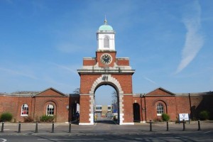
By 1760 the powder magazine in Portsmouth was considered a danger to the many people living nearby and the Board of Ordnance purchased fields on the Gosport side of the harbour, known as Priddy’s Hard. This area was fortified in 1748 and the present magazine and camber were built in 1771. The earlier defences to the Town were in very poor condition so the programme of rebuilding continued, enlarging the defended Town to link up with the new Priddy’s Hard area on the opposite side of Forton lake. These, defences were not completed until 1803 and included a gateway leading to Haslar Hospital (1753).
Within the enlarged defences, privately owned buildings were used for supplying ships, although the area was later purchased by the Navy and would become the victualling yard now known as Royal Clarence Yard. Forton Mill, a tide mill, had been built nearby to provide flour and the remainder of this area was occupied by St. George Barracks. Between 1780 and 1830 the Town developed rapidly, producing some fine buildings, notably in Clarence Square. The tight streets around the Square however provided squalid living conditions and were often patrolled by the naval Press Gangs.
The 19th Century
Robert Cruikshank, a local entrepreneur, planned to develop a seaside spa on land east of the village of Alverstoke. From 1827 to 1831 Thomas Ellis Owen, his architect, designed The Crescent, described as “a piece of grand urban planning of the early nineteenth century….unsurpassed in Hampshire” (Pevsner, 1967). He also designed its flanking villas together with St. Marks Road, where the pumphouse was situated and a garden to the south of the development containing the Bath House (now demolished). The development, although popular with naval officers, was unfortunately never completed. The Crescent’s formal gardens were restored to a Georgian design by the Borough Council and English Heritage in 1991.
The railway came to Gosport in 1841, the main station being in Spring Garden Lane, outside the fortifications. Prince Albert secured permission for a branch to Clarence Yard for Queen Victoria’s use when travelling to Osborne House on the Isle of Wight. A branch line and pier to Stokes Bay were added in 1863 together with a ferry service. The last branch built was to Lee-on-the-Solent in 1894. The now disused railway lines are still evident as is the former terminus at Lee-on-the-Solent.
New Town (or Bingham Town as it was also known) was started in the 1840’s and was the first major development outside the fortifications. The driving force behind this project was the Reverend Richard Bingham B.A., Vicar of Gosport Chapel (now Holy Trinity Church) and the second generation of a notorious local family. Bingham was also a publican, JP, entrepreneur and served six months in prison for fraud! The area has now been redeveloped but Joseph Street and Willis Road are reminders of that period.
In the early nineteenth century, the threat of a full scaled French invasion of the south coast under Napoleon III prompted thoughts of defence again and due to the advances made in artillery technology, the existing defences were considered inadequate to prevent the naval dockyard from coming under attack. An outer ring of defences ordered by Lord Palmerston was started in 1852 with five forts stretching across the peninsula from Gomer to Elson. The Stokes Bay Lines and accompanying Batteries were also constructed, together with Fort Gilkicker on the headland. In the 1880’s the first Victorian terraced houses appeared at Hardway, New Town, Brockhurst and Clayhall between the two lines of fortification. By the end of the century the population had doubled, though fewer were living in the original fortified Town area.
The 20th Century
Boat building had been carried out in Gosport for centuries but probably reached its height between 1900 and 1939 when Camper and Nicholson was synonymous with quality yachts and their famous America Cup contenders for Sir Thomas Lipton (1914) and Tommy Sopwith (1928) in co-operation with the sailmakers Ratsey and Lapthorn. In 1976, Aldey Aluminium built Ted Heath’s “Morning Cloud”. Boats were also built and repaired at Ferrol Road and at Hardway.
In 1922 Gosport and Alverstoke Urban District Council became a Borough and annexed Rowner, a small agricultural hamlet centred around its thirteenth century church. The small seaside town of Lee-on-the-Solent was incorporated into the Borough in 1930.
During the Second World War, the Borough played a major role in supplying the Navy and providing the main submarine base. Grange airfield was used to train pilots and HMS Daedalus housed the “Swordfish” torpedo bombers and seaplanes. The Town area suffered considerable war damage during the blitzes of 1941 with more than half its houses damaged. By 1944, the whole area was bristling with activity and equipment as it provided a major embarkation centre for D-Day. Stokes Bay, Lee-on-the-Solent, Hardway and Gosport Town were all used in this massive operation.
The late 1960’s brought redevelopment to the old Town area which swept away most of the older buildings in the Haslar Road area, Clarence Square and New Town. The old fortifications, originally breached in 1901 to build the school and library (Discovery Centre), were completely removed from the south and west of the town and the moats filled.
The Present and the Future
Since the 1960’s, views about town planning have changed dramatically and the Borough Council has been anxious to ensure the conservation of historic buildings, the town’s rich defence and maritime heritage and the natural habitats of the peninsula. There are now no fewer than fifteen Conservation Areas in Gosport, for example, and the Council has produced a Heritage Strategy to protect buildings of special architectural and historic interest.
The Character of Gosport
The character of Gosport is greatly influenced by its geography and its position as a peninsula dividing the Solent and Portsmouth Harbour. Its tidal creeks are very distinctive, creating a special sense of identity. Although their margins have gradually been altered through reclamation over the years and adapted for a variety of uses, they remain open spaces essential to the character and identity of their surroundings.
The Alver Valley is characteristic of the “urban fringe” where urban and rural land uses meet to create a vivid edge to the built up area. The high quality of its varied landscape and its open links to the Hamble and Solent are major amenity assets to Gosport and a valuable reminder of the peninsula’s former character.
Stokes Bay, with its sweeping line of trees forming an impressive backcloth, has probably the most natural appearance of any urban beach on the South Coast. No. 2 Battery and the remnants of the old fortifications are a vivid reminder of the Bay’s military history and Stanley Park, together with Bay House and Alverbank House surviving in almost their original settings, ad a sense of grandeur. Lee-on-the-Solent also has a fine coastline with the town centre, promenade and clifflands typifying the character of a 1930’s seaside resort. The views across the Solent to the Isle of Wight and the New Forest shoreline are impressive and full of interest.
In Gosport itself, the Esplanade, with its distinctive tower block entrance to the Borough and Portsmouth Harbour, contrasts with and to some extent conceals some of the remaining delights of the High Street area. The short sea crossing between Portsmouth and Gosport has always been a great interest. In the early days, watermen rowed passengers across before steam ferries, such as the well known “Vadne”, became popular. Between 1840 and 1959 small vehicles could be carried across the water on the Floating Bridge to the Ferry Gardens. From the Gardens, the High Street, with its mixture of Georgian, Victorian, Edwardian and modern buildings, forms a distinctive commercial and social centre to the town. Its intimate scale is exemplified by the narrow alleys that lead off the High Street, particularly Bemister Lane.
These general qualities are strengthened by the impact of the naval and military history that surrounds the old town centre. The contribution of St. George Barracks, Royal Clarence Yard, St. Vincents and Walpole Park to the townscape and identity of Gosport is immeasurable. In addition, the remaining Palmerston forts at Elson, Brockhurst, Rowner and Grange (only Fort Gomer has not survived) provide a stark reminder of the perceived threats to Gosport and Portsmouth Harbour in the last century. The presence of Fort Brockhurst in particular alongside the main road into the Borough is impressive.
Elsewhere, the medieval origins of Alverstoke’s street patterns are still apparent. Elson and Hardway have also retained elements of their traditional character, particularly with their views across the moorings in Portsmouth Harbour to Portsdown Hill and the South Downs. Rowner Church and Middle Barn Cottages offer a picturesque centre to the old village, lying in a mature green landscape of copse and open space. This setting contrasts greatly with the Navy’s housing developments to the south.